EXPLAINER: Breaking down PAGASA’s weather terms and alerts
As Super Typhoon Uwan nears landfall, TWCS No. 5 has been hoisted in more areas in Luzon.
This includes the southern portion of Quirino (Nagtipunan), the southeastern portion of Nueva Vizcaya (Alfonso Castañeda, Dupax del Norte, Dupax del Sur), the northeastern portion of Nueva Ecija (Bongabon, Carranglan, Pantabangan), the central portion of Aurora (San Luis, Baler, Maria Aurora, Dipaculao, Dinalungan), Polillo Islands, the northern portion of Camarines Norte (Daet, Talisay, Paracale, Vinzons, Jose Panganiban, Mercedes, Basud), the northern and eastern portions of Camarines Sur (Siruma, Caramoan, Garchitorena, Tinambac, Lagonoy), and the northern portion of Catanduanes (Pandan, Bagamanoc, Panganiban, Viga, Caramoran).
In monitoring the weather system, the Philippine Atmospheric, Geophysical and Astronomical Services Administration issues a variety of alerts with different terms for impact and conditions. It's important to know what these terms mean, as they can help you prepare for calamities.
Here's a breakdown of the key alerts issued by PAGASA and how you should respond to each to stay safe during extreme weather.
Heavy Rainfall Warnings vs. Weather Advisories
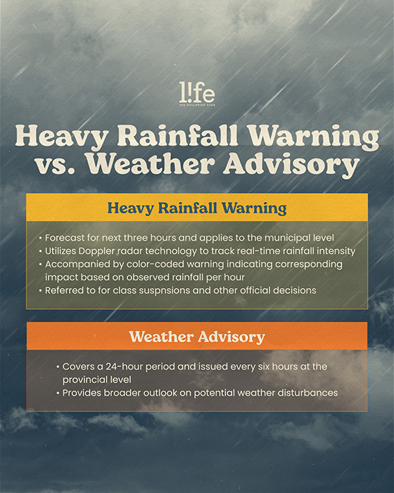
During inclement weather, the country's weather bureau typically issues weather advisories to monitor storms. However, it may also issue a heavy rainfall warning to alert communities of potentially dangerous flooding that requires immediate precautions.
According to PAGASA, the key difference between a weather advisory and a heavy rainfall warning lies in their "forecast period, coverage areas, and accuracy."
A heavy rainfall warning requires more urgent attention as it provides forecasts for the next three hours and applies up to the municipal level.
"It is more precise as it utilizes Doppler radar technology to track real-time rainfall intensity, making it highly effective for immediate decision-making in flood-prone areas," PAGASA stated.
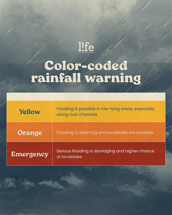
It is also accompanied by a color-coded warning, such as yellow, orange, and red, each indicating corresponding impacts based on observed rainfall per hour.
Yellow means that flooding is possible in low-lying areas, especially along river channels. Orange signals that flooding is alarming and landslides are possible, while red is the most dangerous as it means that the flooding is serious and damaging and has a higher chance of landslides.
A weather advisory, meanwhile, covers 24 hours and is issued every six hours only at the provincial level. While it provides a broader outlook on potential weather disturbances, it lacks the short-term accuracy of a heavy rainfall warning.
Because of this, heavy rainfall warnings are the ones that need to be checked for class suspensions or other official decisions.
What are Tropical Cyclone Wind Signals?
PAGASA also details Tropical Cyclone Wind Signals in their alerts. This serves as a warning to a particular land area that may experience winds of at least strong breeze in strength on the Beaufort Scale within at most 36 hours from the time the signal is put into effect during the passage of a tropical cyclone.
There are five signals in total, and each one has an equivalent expected wind threat, length of time in hours before onset of expected wind threat, and potential impacts to the locality.
TCWS No. 1 is issued for Tropical Depressions or higher, having strong winds of 39 to 61 kilometers per hour. Its warning lead time is 36 hours.
It could potentially damage houses of poor construction (e.g., wood frame, bamboo, makeshift), old, dilapidated structures, and other structures made of light materials will suffer minimal to minor damage. Signal No. 1 could also bring minimal disruption to public transport, cause banana and similar plants to tilt, and twigs of small trees to sway. Rice crops, especially those in the flowering and ripening stages, may suffer some damage.
TCWS No. 2 is issued for Tropical Storms or higher, having gale-force winds of 62 to 88 kilometers per hour. Its warning lead time is 24 hours.
This signal could cause minor to moderate damage to makeshift or old dilapidated structures, and other structures made of light materials. Houses of poor and average construction (e.g., unreinforced CHB/masonry, mixed timber-CHB) may receive minor roof damage. Some electrical wires may be blown down, resulting in local power outages, and areas under this TCWS may experience minor to moderate disruption to public transportation.
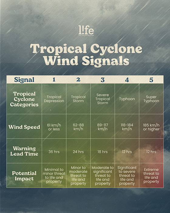
TCWS No. 3 is issued for Severe Tropical Storms or higher, having storm-force winds of 89 to 117 kilometers per hour. Its warning lead time is 18 hours.
Well-constructed houses may suffer minimal to minor roof damage, and many areas may experience power outages.
Meanwhile, TCWS No. 4 is issued for Typhoons or higher, having typhoon-force winds of 118 to 184 kilometers per hour. Its warning lead time is 12 hours.
Most well-constructed houses may suffer minor to moderate roof damage, with some houses experiencing major roof failure; blown-out windows are also likely.
The last signal, TCWS No. 5, is issued for Super Typhoons, having typhoon-force winds of 185 kilometers per hour. Its warning lead time is 12 hours.
It's expected to cause severe to catastrophic damage to houses of poor or average construction, makeshift or old, dilapidated structures, and other structures made of light materials. People in areas with TCWS No. 5 may also experience disruption in infrastructure and public transportation.
What is a Flood Advisory?
For floods, PAGASA also has its own set of warning levels issued for river basin centers like Pampanga, Agno, Bicol, Cagayan, Cagayan De Oro, and the like.
Water level is monitored based on the assessment levels Alert, Alarm, and Critical, which means 40%, 60% and 100% of the river is full, respectively.
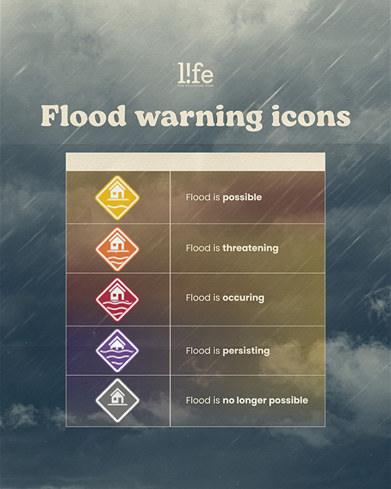
A yellow warning icon means that there is a slow rise in water level and that a flood is possible, while an orange icon signals that the water level is continuously rising and a flood is threatening.
A red icon means that the water level is above the critical level and a flood is occurring, whereas a purple icon indicates that the water level is continuously rising above the critical level and the flood is persisting.