The deadliest risks of potential super typhoon Uwan (Fung-Wong), explained
Uwan, which is forecast to become a super typhoon, could cover the entire Philippines and test our resilience to the limit, a climate change and disaster risk expert said. He, however, noted that it goes beyond how big it could get.
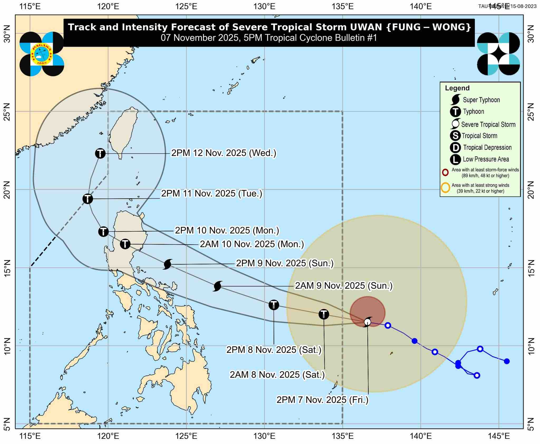
According to PAGASA's 11 p.m. bulletin, Uwan has entered the Philippine area of responsibility on Friday evening, Nov. 7. It has reached typhoon category as of 8:00 p.m., and may reach super typhoon category by Saturday evening or the following morning.
By then, award-winning scientist Glenn Banaguas said, it will no longer be just a weather disturbance but “a full-blown disaster in motion.”
“Uwan is so large that its wind and rain bands could blanket the whole archipelago,” he told PhilSTAR L!fe, “but it’s not just about size. It’s about reach, timing, and intensity.”
How huge is it?
The Office of Civil Defense on Friday afternoon explained how big Uwan can get. “Napakalaki nitong bagyo. Ang radius nito ay 700 kilometers from the center—times two, 1,400 kilometers in diameter. Batanes to Bohol ang maaaring maapektuhan,” Civil Defense Deputy Administrator for Administration Bernardo Rafaelito Alejandro IV said in a press briefing.
"Picture yourself drawing a straight line from Batanes in the north to Bohol in the south—that’s more than 700 kilometers. Now, picture a storm so wide that its winds could stretch across that entire line. That’s how big Uwan is," said Banaguas.
"It’s like throwing a giant stone into a lake and watching the ripples reach every shore," he continued. "With a storm this size, no place is truly far enough."
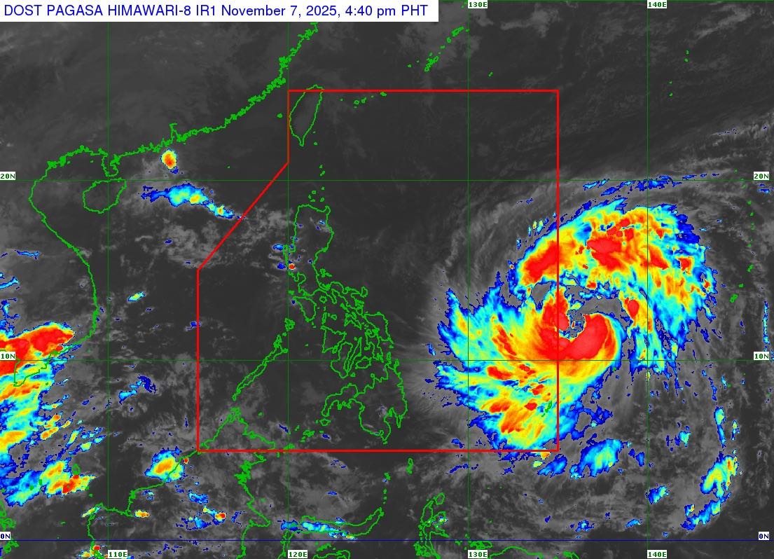
Per the state weather bureau's 8 p.m. bulletin, Uwan is packing maximum sustained winds of 120 kilometers per hour near the center and a gustiness of up to 150 kilometers per hour.
A gustiness of 150 kph must be considered a warning. “Winds reaching this aren’t just strong—they’re forceful enough to reshape a landscape in minutes.”
Banaguas put it simply: “Imagine standing on a highway with a car speeding past you at that exact speed. Now, imagine that speed not in one direction, but swirling around you, pressing against walls, trees, rooftops, and power lines all at once.”
Such gusts, he added, don’t arrive gently. “They slam into surfaces with sudden bursts, often catching communities off guard. And when paired with heavy rain, they can drive water sideways into homes, break windows, and make rescue operations extremely risky.”
How much rain could there be?
Banaguas noted that the wind is just one part of the threat.
"Uwan could carry enormous amounts of rain so much that rivers overflow, hillsides collapse, and streets turn into rivers. In coastal areas, the sea itself can rise and push inland, flooding homes even before the rain begins," he told L!fe.
It's forecast to bring more than 200 millimeters of rain to areas under red rainfall warning, which means “widespread incidents of severe flooding and landslides are expected,” per PAGASA. These include Camarines Sur, Catanduanes, and Albay.
"More than 200 millimetres of rain in 24 hours is enough to flood entire communities, especially in low-lying or poorly drained areas," Banaguas explained. "It’s not just a downpour—it’s like emptying hundreds of bathtubs over every square meter of land, triggering flash floods, landslides, and drainage collapse."
What makes it dangerous?
According to the disaster resilience expert, what makes Uwan dangerous is how slow and wide the storm is.
"Since Uwan is moving slowly, the rain doesn’t pass quickly. It lingers, hour after hour, turning quiet barangays into lakes and valleys into rivers," he said. "This kind of rain doesn’t just soak the ground; it overwhelms it. Rivers swell, roads disappear, and slopes give way. In cities, drainage systems can’t keep up, so water backs up into homes and streets. In the mountains, saturated soil turns unstable."
It could also "test every weak point" in our infrastructure as the winds "don't just blow but grind, wearing down rooftops and trees over time."
"This kind of scale overwhelms systems," he said. "Emergency responders can’t be everywhere. Roads get blocked in multiple provinces. Rivers overflow in places that aren’t used to flooding. Even areas that usually serve as evacuation centers might be affected themselves."
Uwan could affect thousands of lives not just through wind and rain, but through flooding, landslides, and long-term disruption. "It’s a reminder that storms are getting stronger, and we need to be ready not just with warnings, but with real resilience."
How to prepare
Storms like Uwan don't always show up with dark skies right away. "Right now, while the weather seems fine, the storm is still gathering strength over the ocean," per Banaguas. "It’s moving closer, feeding on warm waters, building up wind and rain that it will eventually release over land."
"The danger isn’t gone—it’s just not visible yet," he said.
When a super typhoon is on the horizon, preparation is a commitment to protect what matters most. "When the storm finally arrives, it won’t wait for anyone to catch up. What you do today could be the reason you’re safe tomorrow."
Here are five essential actions every household and community should take, according to Banaguas.
Secure your home like you’re expecting a fight
"Tie down anything that can fly away. Reinforce windows. Check your roof. Even small objects outside like buckets or garden tools can become dangerous when the wind picks up."
Charge everything
"Phones, flashlights, radios, and power banks. Once the electricity goes out, these become your lifeline to information, coordination, and help."
Stock up wisely
"Prepare food that doesn’t need cooking, clean water, basic medicines, and hygiene items. Think of what you’d need if you couldn’t leave your house for three days."
Know your exit
"If you live near rivers, coastlines, or slopes, know your evacuation routes and shelters. Don’t wait for the water to rise—move early if advised."
Talk to each other
"Check on neighbors, especially the elderly and those with disabilities. Share plans. A prepared community is stronger than any storm."
"Yes, Uwan could cover the entire country, but more importantly, it could stretch our resilience to the limit. That’s why early action matters not just in one province, but across the entire nation," Banaguas said. "When a storm is this massive, the only way to face it is together."